


Toronto Fire Insurance Atlases & Plans

Fire insurance atlases and plans are detailed maps used to research the history of buildings and neighbourhoods. Atlases cover the city as a whole. Plans cover specific neighbourhoods and often have more detail than atlases.
You can view our holdings online (1858 to 1912) or in person (1858 to 1973).
Digitized fire insurance maps
This list includes maps from Toronto Public Library as well as other institutions.
Our atlases and volumes of plans are large PDFs with pages presented in their original order. Easier-to-navigate versions with clickable pages are available from other sources. Learn about external sources in this index.
Below is a map that shows approximate coverage of the volumes of plans. (Volumes 10 and 11 are not available digitally.)

Atlases
1858
1880
1884
- Toronto Public Library (PDF)
- City of Toronto Archives
- Library and Archives Canada
- Mapping Toronto History
- Nathan Ng
- University of Toronto
1890
- Toronto Public Library (PDF)
- City of Toronto Archives
- Library and Archives Canada
- Mapping Toronto History
1893
1894
1899
- Toronto Public Library (PDF)
- City of Toronto Archives
- Library and Archives Canada
- Mapping Toronto History
- Nathan Ng
- University of Toronto
1902
1903
1910
- Toronto Public Library (PDF)
- Library and Archives Canada, Volume 1
- Library and Archives Canada, Volume 2
- Library and Archives Canada, Volume 3
- Mapping Toronto History
- Nathan Ng
1912
- Toronto Public Library, Volume 1 (PDF)
- Library and Archives Canada, Volume 1
- Library and Archives Canada, Volume 2
1913
1923
1924
Volume 1 plans
1889
1892
1909
1918
Volume 2 plans
1889
1910
Volume 3 plans
1911 to 1914
Volume 4 plans
Volume 5 plans
1890 to 1904
1907
1907 to 1914
Volume 6 plans
Volume 7 plans
1915
Volume 8 plans
Volume 9 plans
1897 to 1916
Volume 12 plans
1903 to 1918
Other plans
Parkdale, 1882
Yorkville (St. Paul's Ward), 1884
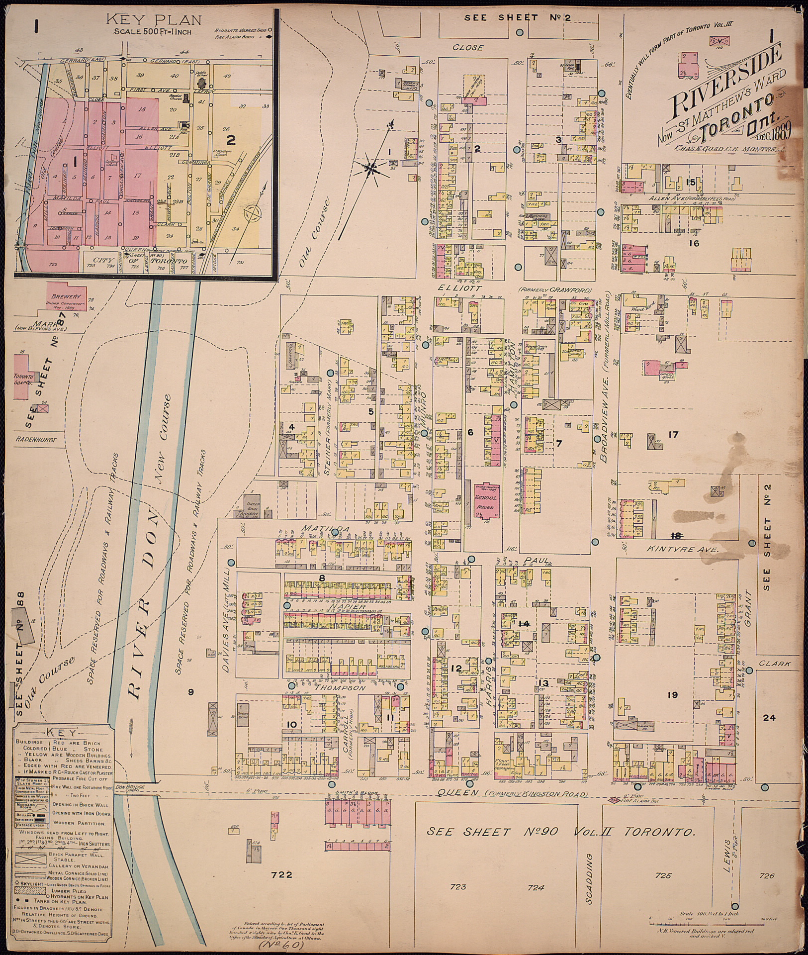
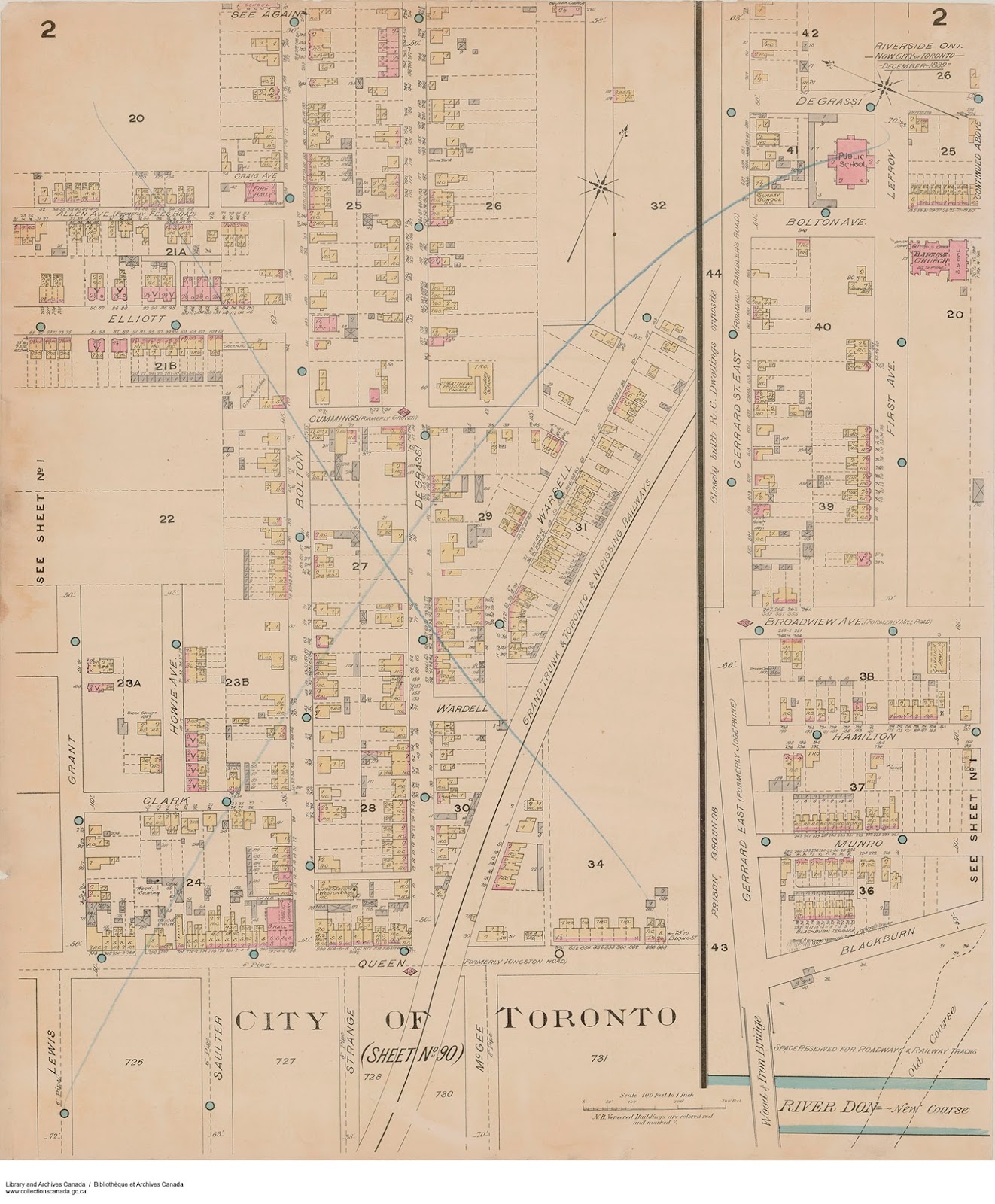
Riverside (St. Matthrew's Ward), 1889
- Found in: Volume 2, 1889 | PDF (Toronto Public Library). Pages 51 and 52.
- Nathan Ng, sheet 1
- Nathan Ng, sheet 2
- Library and Archives Canada
West Junction, 1889 to 1892
- Found in: Volumes 1 and 2 | PDF (Toronto Public Library). Key plan and sheet 1, page 101; plate 2, page 102; plate 3, page 103; plate 3 (with inserts), page 104; plate 4, page 105; plate 5, page 106.
- Nathan Ng, key plan and sheet 1 (third key plan)
- Nathan Ng, sheet 2
- Nathan Ng, sheet 3 (with inserts)
- Nathan Ng, sheet 4
- Nathan Ng, sheet 5
Fires, 1895
- Library and Archives Canada, January
- Library and Archives Canada, March
- Nathan Ng (includes 1904 fire)
Fires, 1904
G.T.R. [Grand Trunk Railway] Elevators No. 1 & 9, 1900
Mimico including New Toronto, 1913
Fire insurance maps available in person
Many of these maps - including those under copyright - can be viewed at Toronto Reference Library. Our finding aid lists what's available, with links to the catalogue records.
Finding aid for non-digitized fire insurance maps
About these maps
Fire insurance maps can be hard to understand at first glance. Learn about their history, current uses and tips on how to read them.
History
Overview
Fire insurance atlases (consisting of pages called "plates") and plans (consisting of pages called "sheets") are detailed large-scale maps of cities, smaller municipalities and industrial sites.
These plans were prepared for and leased to insurance companies who used building sizes and construction materials to determine the fire risk and therefore to be able to quote insurance premiums to customers.
Plans and atlases were updated frequently as buildings were burned, torn down, rebuilt or new areas were developed. When minor corrections were necessary, revisions were printed and distributed to the agents to paste over outdated sections of the maps. This sometimes resulted in multiple layers and plans with the same date having different revisions.
New editions were only published periodically, when major changes took place. Agents were required to return the outdated plans to the mapping company, in order to receive revised plans. These returns were destroyed.
Coverage of Toronto and its neighbourhoods
The forerunner of fire insurance mapping of Toronto was the 1858 Boulton atlas. At one inch to 100 feet it was the largest scale map of Toronto produced to that date and the first to show construction materials of building.
Charles E. Goad (1848-1910), who initiated fire insurance mapping in Canada in 1875, produced his first fire insurance plan of the city of Toronto, Ontario in 1880 (revised in 1889 and 1892). It consisted of two volumes of large sheet maps at the scale of one inch to 50 feet (relative scale 1:600). Plans measured 54 x 64 cm, or 21 x 25 inches.
Generally only developed areas (usually those within the city proper) were included. Maps of outlying areas were not produced unless they were built up. Thus, separate plans for places such as West Toronto Junction and Yorkville were prepared in the 1880s.
Detailed plans sometimes were provided of commercial and industrial sites, either within an atlas itself (e.g. Consumers' Gas Company and Gooderham and Worts in 1880, or as separately issued plans (e.g. the Grand Trunk Railway Elevators in 1890).
Beginning in 1910, the expansion of Toronto led to the production of multiple volumes of plans, with each volume covering a different part of the city. The amount of detail varied; it was usually intense in the city core and for major buildings, while buildings further from the city centre, when represented at all, were shown only by outline and type of structure. Revisions to these area volumes were frequent from the turn of the century to the 1940s in response to changing development and growth in Toronto.
In 1917, Goad's sons sold the business to the Canadian Fire Underwriters Association, who published plans under the imprint of Underwriters' Survey Bureau Limited. In 1965, the USB became the Plan Division of the Canadian Underwriters' Association.
The final Insurance Plan of the City of Toronto was produced between 1952 and 1973. At one inch to 100 feet and measuring 30 x 33 cm, or 13 x 13 inches, they were smaller in scale than earlier plans and kept in binders. In 1974, the Insurers' Advisory Organization took over production of Canadian plans, but in 1975 ceased production of fire insurance plans due to escalating cost.
Current uses
Today, researchers find fire insurance plans an invaluable information source, using them for a variety of purposes, including to:
- narrow the date when a building was constructed
- determine earlier street numbers of individual buildings and previous names of streets which may have changed
- locate a building on the street and in relation to other buildings on the block. This is useful in resolving confusion that sometimes happens in directory research. Sometimes a directory will indicate that a building, which is now located in mid-block, as being at the corner if no closer buildings to the corner have yet been built.
- determine the lot number, block number (if there is one), and the registered plan number of a property. These can be useful with assessment and title searches.
- indicate buildings that may have been demolished or recently constructed
- track how buildings have been used and altered over time
- indicate a building in relationship to its neighbourhood, such as schools, churches, industries
- show how a neighbourhood has changed over the years
- indicate sites where soil may be contaminated from former noxious uses
Tips for reading
Below is a key to the symbols, colours and abbreviations (1880 to 1892).

External sources
Nathan Ng's Blog - Recursion
Key maps from fire insurance atlases with clickable links to jpeg files of individual plates within each atlas.
City of Toronto Archives
Key maps from fire insurance atlases with clickable links to jpeg files of individual plates within each atlas.
ESRI Toronto Historic Maps
Single map compiled from multiple fire insurance maps that enables users to view specific locations as they appeared at different points in time.
Library and Archives Canada
Searchable database of Toronto Fire Insurance Plans with thumbnail links to individual plates within each atlas.
Mapping Toronto History
Six atlases sourced from Toronto Public Library with clickable links to individual plates overlaid on Google Maps.
University of Toronto
University of Toronto Map and Data Library has digitized and georeferenced out-of-copyright fire insurance maps to create an interactive map. To view different years for a given atlas or plan, adjust filters.
Bibliographies and catalogues
- Catalogue of Canadian fire insurance plans, 1875-1975
- Canadian fire insurance plans in Ontario collections, 1876-1973
- Finding aid for fire insurance plans held by Canadiana.
Note: most of these plans are now housed in the Toronto Reference Library. - Fire insurance plans in the National Map Collection = Plans d'assurance-incendie de la collection nationale des cartes et plans